Very hot Wed-Thu, getting cooler on Fri (max temp will be before 12). Getting cooler later on.
High level of dust
This level is dangerous for outside activity. In a couple of hours it will decrease so in the evening it will be with a low level of dust.
Android: new version
Many small improvements and updates.
Go to the Google Play Store.
Have you missed the heavy heatwave?
It is coming next week
Rain around noon
The rain is expected in the eastern parts and could touch the city also
Warming up
Tomorrow there is a chance of a short shower, but warm. On Tuesday jump in heat. Heatwave on Wed-Thu. Later on around 25 degrees.
Warm with a chance of rain
Partly cloudy and sunny with light cloth on Fri-Sat-Sun. On Sun-Mon upper cold air will pass and it could bring some insignificant showers.
rain is coming
The rain is expected to arrive within 20 to 45 min
Unstable till Sunday, then heatwave
Till Sunday night there could be rain here and there. Later on next week, it will develop to heatwave on Wed.
rain is coming
The rain is expected to arrive within 90 to 120 min and will stop by 14:00.
rain is coming
The rain is expected to arrive within 20 to 45 min esp to the west parts
Rain from Tue afternoon till Wed noon
This is the window opportunity with good conditions for a significant event. showers with thunder can happen.
Chance of rain in every day
Noon-afternoon rain on Sun-Tue. Wed with longer rain. Generally, chilly week.
Cooling on Saturday
We are not in Summer. Hot Thu-Fri, but after them we are getting cooler to like-average temps which are not-cold-not-warm.
Chance of drizzle in the next hour
Clouds have developed in the mountains region
Hot week, mild week
This week will be under heatwave with temps 5-7 above average. Next week will be like the average with a chance of rain.
Nicer than usual sunset now
Your attention is recommended
Dusty or not that is the A
Gray in the sky and hot does not mean dust or haze. These are clouds.
Dust is when you look into the horizon and it is not cristal clear.
For whom that has taken a coat today
Also take tomorrow
Closet change is doable
April is expected to be hot with only a few rainy and chill days.
It is the coldest day in the coming era
Warming up from tomorrow to the 25 degrees region plus-minus on the horizon
light rain is coming
The rain is expected to arrive within 60 to 90 min esp to the west parts
Light rain is coming
The rain is expected to arrive within 30 to 45 min esp to the north parts
rain is coming
The rain is expected to arrive within 30 to 60 min esp to the west parts
Towards heatwave
Sun-Mon with a lot of clouds without rain almost because the rain will be mostly in the south of the country. Tue with strong wind, Wed-Thu with a heatwave, Fri the heatwave ends.
Light rain is coming
The rain is expected to arrive within 10 to 20 min
Rain amount from yesterday 76mm
459mm from the season start, missing yet 65mm for the rain season complete.
break is coming
The rain is expected to pass within 20 to 45 min
rain is coming
The rain is expected to arrive within 30 to 60 min
break is coming
The rain is expected to pass now for 45 min or so
rain is coming
The rain is expected to arrive within 20 to 45 min esp to the south parts
break is coming
The rain is expected to pass within 45 to 60 min
rain is coming
The rain is expected to arrive and will last for the coming hour. Local rain
It is getting closer
Some limited rain in the afternoon and esp in the evening. After midnight upper cold air will arrive, jet stream will move east, so rain with hail and thunder will fall till noon, decreasing after that.
Instability till next Sunday
2 waves of rain are expected: Monday night till Tuesday afternoon and Thursday eve till Friday noon, some leftovers can be later. Between rain waves there will be more springy weather than wintry.
Significant rain
From Monday evening to Tuesday evening, it is going to be intense. Winds, strong showers, chance of hail and thunder.
A look till the end of month
Outlook by ensemble forecast runs: Next week will be chilly with some rainy days. The week after will be hot till heatwave style.
Warming up, chilly weekend
Springy Tue-Wed, chilly Thu-Fri-Sat, rain in a week. Dry wind on Tue, hotter Wed.
Next rain maybe on Sunday
This week we are getting warmer without the need for heating from Tuesday.
Prepare the t shirt collection
Significant warning from Tuesday
break is coming
The rain is expected to pass within 20 to 30 min
Sun get stronger between rain periods
Wed with big change in the middle with strong wind, Thu with rain, Fri with nice weather for the Marathon, Sat with rain, Sun-Mon with warmer weather towards somewhat heatwave later on.
rain is coming
The rain is expected to arrive within 45 to 90 min esp to the west parts
Fri Marathon seems without rain
Weather will be cool and cosy for running. It is not final, because not all models agree.
Decreasing
Later the day some rain will continue here and there, mostly not
Status
Rain cells moving from WNW. Light-medium rain in the coming 1-2 hours.
Break
Change is happening, temps drop and clouds will enter
The winter with highest minimum temp
February is over and with that, we have concluded the three main winter months. The nights were among the warmest if not the warmest from 1950.
Rainy next weekend
The day of the Marathon is expected to be rainy and cold. From morning or towards noon? only 3 days ahead.
Warmth between rainy days
Windy on Thu-Fri-Sat with high temps. Rain on Sunday. Next rain will be hopefully on next weekend.
Rain is over
Go to vote
break is coming
The rain is expected to pass within 10 to 30 min
rain is coming
The rain is expected to arrive within 20 to 60 min esp to the west parts
Status
Rain cells have begun developing in the Negev. Rain is expected in a couple of hours in our region.
Status
Rain at the shore in the morning, at the mountains around noon-afternoon from locally generated clouds. Go to vote
Rain tomorrow
Clouds will develop in place and will generate local rain with a chance of thunder. Not every point will get rain.
Nicer than usual sunset
A wide spread of high clouds along with a few medium clouds could bring nice colors at 17:30
Cold only in the morning and evening
Temperatures in the coming wek are not like in the center of winter. Tuesday will be with only a couple of rain showers around noon and afternoon. Another rain is possibly on Saturday-Sunday.
break is coming
The drizzle is expected to pass within 20 to 40min
Rain on Tue
Warm till Monday with a a lot of clouds on Fri-Sat. On Tuesday short system with a lot of energy for a day.
rain dose is coming, if will not collapse on the w
The rain is expected to arrive within 120 to 180 min
Clouds in the sea in our way
It seems a break in the coming 2 hours
Another dose
After this dose break of 30-45min and then another short one.
Looking far away
Temps of above 20 with jumps from day to day on the horizon of 10 days. Winter is (not officially) over as critical mass and will come back with episodes here and there.
short rain is coming
The rain is expected to arrive within 30 to 60 min
break is coming or decrease at least
The rain is expected to pass within 20 to 45 min
Continues rain in the coming hours
Large cells of rain moving from NW
Short rain is coming
The rain is expected to arrive within 20 to 45 min esp to the west parts
light rain is coming
The rain is expected to arrive within 30 to 60 min esp to the west parts
rain is coming
The rain is expected to arrive within 90 to 120 min esp to the west parts
rain is coming
The rain is expected to arrive within 30 to 60 min esp to the west parts
rain is coming
The rain is expected to arrive within 60 to 90 min esp to the west parts
Rain cells in the right direction but collapses
Chance of rain in the coming hours mainly to the west side
Something is rising
Chance of rain in 90 min or less
Only on Monday cards will be as wanted
Sunday with showers. In the night there will be renewal in energy and the low system will move to the right place, so Monday is the rainy day
Still a low chance of rain
Till early morning there is a chance for small light shower
It seems rain will not come today
Rain line going north
Sunday is the rainy day
Friday with a few showers. Saturday is rain-free, Sunday with tidy rain, Monday with leftovers.
rain is coming
The rain is expected to arrive
40-50% chance for above 10mm this afternoon
But it could fall near us and not exactly on us.
Chance of rain
Deep instability in the coming hours could lead to rain cells building in minutes. Most of the rain is in the sea, but we could get that too.
6 days with rain
Wed-Fri - showers could be strong but limited in time. Most of the time without rain. Sat-Rain - more consistent rain. Monday - leftovers.
When shorts?
It is known that children like to go to school with shorts in any condition. So, generally, when the cloth are green and above and it should be sunny it is possible to let them in the winter.
It is warmer
This evening is warmer in 3 degrees. Tomorrow the same
Rain system on Wed-Sat
Days Sunday-Tuesday will be warmy, Monday-Tuesday will be cloudy, though. On Wed low system will arrive to Cyprus which will result with rain, but less in our region. The location is too western and most of the rain will be in the north&shore.
Rain cloud development
Starts in the inland area. In an hour or 2, it could reach our region.
The unbearable
The unbearable easy of 18 degrees two days after cold period of real winter.
Chance of rain in the coming 2 hours
Rain wave is developing on the mountains
Warming with rain on the horizon
No coat on Wed-Thu-Fri, rain (possible) on Sat, Sunny-dry-wind on Sun-Mon, rain later on (mid week).
break is coming
The rain is expected to pass within 20 to 45 min
Rain is coming
within 45 to 60 min rain will become more serious
Light showers are coming
The rain is expected to arrive within 20 to 45 min
Afternoon-evening dose
Showers are expected
Scratch in the northern parts
Rain is expected in the coming hour
Next dose
In 2 hours or more, the next dose is expected. Clouds are in the sea right now.
break is coming
The rain is expected to pass within 30 to 60 min
rain is coming
The rain is expected to arrive within 45 to 60 min esp to the west parts
rain is coming
The rain is expected to arrive within 30 to 60 min esp to the west parts
rain is coming
The rain is expected to arrive within 30 to 60 min esp to the south parts
This evening
Rain is possible after 20:00 with 8 degrees, cold that deserve gloves.
rain is coming
The rain is expected to arrive within 20 to 45 min esp to the west parts
Rain is not seen in the coming hours
Rain could fall in the afternoon
rain is coming
The rain is expected to arrive within 30 to 60 min esp to the west parts
break is coming
The rain is expected to pass within 60 to 90 min
Most odds it will not be stormy
The strong low enters to the south. We will get showers.
Passing low on Thu night - Fri morning
A small intensive low arrives on the shore and could bring locally stormy weather. its touch range is not decisive so it could end up with nothing.
The rain mainly target west and north
Will come in 15-30 min
rain is coming
The rain is expected to arrive within 20 to 45 min
Classic FOMO
A situation where the action goes elsewhere, will be also tomorrow. Rain could be this evening-night.
rain is coming
The rain is expected to arrive within 60 to 90 min
break is coming
The rain is expected to pass within 10 to 30 min
rain is coming
The rain is expected to arrive within 10 to 20 min esp to the west parts
rain is coming
The rain is expected to arrive within 60 to 90 min
rain is coming
The rain is expected to arrive within 10 to 20 min esp to the west parts
Decrease in precipitation
The system moves to the west into the sea which causes precipitation to move away. Large breaks and concentration in the afternoon-evening on Sunday-Tuesday. On Wed-Thu it will be the coldest but almost without precipitation. No **** is expected.
rain is coming
The rain is expected to arrive within 10 to 20 min
rain is coming
The rain is expected to arrive within 20 to 30 min
short rain is coming
The rain is expected to arrive within 30 to 45 min
Long break
Till the night hours light rain only.
rain is coming
The rain is expected to arrive within 45 to 60 min
rain is coming
The rain is expected to arrive within 20 to 30 min esp to the north parts
Large break of more than an hour
Lighter showers later on
rain is coming
The rain is expected to arrive within 10 to 20 min
rain is coming with thunder
The rain is expected to arrive in all parts of the city within 30 to 60 min
rain is coming
The rain is expected to arrive within 20 to 30 min esp to the north parts
From the afternoon will become rainy till morning
Rain line will make the way to the south and we will get all the good and a lot
break will cone
The rain in the north is expected to pass within 10 to to 20 min
rain is coming
The rain is expected to arrive within 10 to 30 min esp to the north parts
break is coming
The rain is expected to pass within 20 to 45 min esp to the south parts. In the north parts it could continue
rain is coming
The rain is expected to arrive within 60 to 90 min
Rain here and there
Only at night rain will increase towards rainy day tomorrow
Still far away
Disagreement with how the cold day will be, Tuesday with timing and precipitation, but with not being cold enough for a white event as we love.
For Mon-Tue
Ye, it will be very cold, but, not enough for s***. It is long range, changes could occur. keep updated.
rain is coming
The rain is expected to arrive within 20 to 30 min esp to the west parts
rain is coming
The rain is expected to arrive within 30 to 45 min esp to the north parts
break is coming
The rain is expected to pass within 10 min
rain is coming
The rain is expected to arrive within 60 to 75 min
break is coming
The rain is expected to pasue for an hours
rain is coming
The rain is expected to arrive within 20 to 30 min esp to the west parts
Rain postpones
Only drizzle could come in the coming hour
rain is coming
The rain is expected to arrive within 90 to 120 min
It starts tomorrow
Even tonight it can rain slightly. Rain tomorrow will fall nicely mainly around noon-afternoon. less on Wed. Some drops on Thu. Will become stormy during Fri.
Rainy period
Scneario of 8-10 days of rain is not unlikely. Fry-Sat-Sun-Mon seems like the peak.
Wintry from Tue
Very mild Sun-Mon, continues the weekend. On Monday afternoon there will be a change with cooling. From Tue rain is expected every day with cloudy days. It will increase on the weekend. There is no talk about s***.
Between 2 weekends
The coming weekend (and the start of the next) will be very warm, but the next will be rainy and cold. Could be very cold.
Money time
The way to a major system in our region goes through high in western Europe. This happens in next week. Will this momentum make its way?
Next rain on next week start
Till then a couple mild days without a coat towards the weekend.
rain is coming
The rain is expected to arrive within 30 to 45 min esp to the west parts
Break
In the coming 1-2 hours rain is concentrated in other places
We passed 200mm seasonally
86% from what should have been falling till now.
Break before next rain
The rain is expected to arrive within 60 to 90 min esp to the west parts
Nicer than usual sunset
Your attention is recommended at 16:40
Rain has stopped totally
Next is on Sunday
Train of clouds in the coming hour
The rain line goubg north, but a train has managed to develop, causing rain in the coming hour, after that, the rain is expected to pass within 60 to 90 min
Rain line getting northern, rain trend decrease
The rain is expected to arrive within 20 to 30 min esp to the west parts
Status
A bit of a break for 30-40min and then another dose of rain for 30 min
rain is coming
The rain is expected to arrive within 10 within 20 to 30 min esp to the south parts
break is coming
The rain is expected to pass within 10 min for an hour or so
Status
Continues cloudiness with little holes. Continued rain is expected in the coming hours.
Status
Medium size rain cells coming from the west. Rain on and off by ~30 min intervals.
Major rain is coming
The rain is expected to arrive within 30 to 60 min
rain is coming
The rain is expected to arrive within 30 to 60 min
Rainy day tomorrow
Till noon some breaks are expected. From ~noon rain should be continues or almost continues.
Horizon is mild
The second system is a bit minimized because European activity. After that we are back to non active and above usual temps winter.
Two systems on the way
The first is pushed by the second, which will be, in consciousness, stronger and colder.
Nicer than usual sunset
Your attention is recommended now and till sunset
Winter shift gear
We are towards the next phase of winter in which we are getting into the usual temperature values of winter with small systems with nice rain on Thu-Fri and Sun-Mon.
two and a half warm days
Sun-Mon-Tue will be with nice high clouds without a need for a coat. From Wed there will be cooling.
rain possibly is coming
The rain is expected to arrive within 60 to 120 min esp to the north parts
rain is coming
The rain is expected to arrive within 45 to 60 min esp to the west parts
Nicer than usual sunset
Your attention is recommended around 16:46
Winter Nuances
Upper shallow trough passing by, making a chance of mainly light rain, here and there, on Tue, Wed, Thu evening and Fri.
10 days with same trend
Only after the first 10 days there could be a change into real winter.
2023 was among the hottest
Looking nationality, it is the second hottest, together with 2016.
Autumn systems in the winter
On Tue and Fri there could be some limited rain. The activity center is in Europe and we are getting little rain and high temps. The most sunny day will be Monday.
Mild winter with minor rain
Into the deep of January, we will continue with the trend of mild winter or winter that almost not exist.
A bit of rain today
Rain could fall this afternoon and in the evening-night. No significant rain. Source of the rain is from SE.
Looking forward
Warmth till Sunday. From Monday, it is colder with insignificant rain here and there. It could develop into something more serious in a few days.
App is up again
The issue has been fixed
break is coming
The rain is expected to pass within 40 to 60 min
break is coming
The rain is expected to pass within 20 to 45. Drizzle is still possible.
Rain will renew
After a short break, new clouds are coming. Generally, rain will decrease in the coming hours, though.
break is coming
The rain is expected to pass within 30 to 60 min
Increase in rain
We are getting into hours of rain getting more to the south, starting to be in our way.
Wind will decrease on Sunday
A lot of wind today and on Saturday. Gusts up to 70 kmh.
Nicer than usual sunset
Your attention is recommended at 16:35
Rain on Sat-Sun
The exact azimuth of the westerly streams is not determined by the weather models yet. Most of the rain will bypass our region. Chances exist on Sat and Sun.
Rain on Saturday? less. On Sunday
Wide westerly streams bring a lot of rain to the levant. Less to JLM. Rain line will be cut on Sat right in our region, making some chances of rain. Higher chances on Sunday.
Colder in the coming days
Colder Monday, a bit more on Tue. Wed with really chilly feeling with dry wind. Thu will be already passed. Generally , it is not yet the hardcore chill of winter. Rain only on next week.
Dry period
No significant rain system is seen. A lot of dry wind days without very low temperatures.
rain is coming
The rain is expected to arrive within 60 to 90 min
Break
Right now there is no additional rain, but another shower is expected in the afternoon
rain is coming
The rain is expected to arrive within 10 to 20 min
rain is coming
The rain is expected to start within 45 to 60 min
Drastic change in the afternoon
Sky will get cloudy with a chance of temporary strong showers. At night around midnight there will be the main course with likely thunders, till early morning. During Wed morning good chance of rain, decreasing hours later, chances still remain till evening.
Rain for a day
On Tuesday the main rain dose will be in the night. Wintry on Wed, cold Thu, then getting warm again for 5 days.
Tropical wave on Monday
On Fri-Sat there will be rain, but not in our region (maybe some tiny amount in the night). On Monday some clouds will be coming from the south, which could be bypassed. On Tue-Wed it will be wintry with showers. Later on, some warm days.
Fog in the valleys
Tomorrow morning blanket of clouds should lay in the lowest places, should be a nice sight
Chance of rain
Rain cell pass the shore and could reach (low chance) the northern parts of the city.
rain is getting more serious
Intensive rain is expected to arrive within 20 to 45 min
rain is coming
The rain is expected to arrive within 30 to 60 min. Currently, it will be on and off. In a few hours it will get more intensive.
A look forward
The warmth will continue with a lot of clouds. Rain on the weekend is almost dismissed. The next will be on Tuesday.
Afternoon evening rain
Significant rain is expected that could reach above 15mm.
two digit temps
The average for December is 9-15, but in the next 10 days it will be above it. Very mild winter.
Two warm days and cooling
Dusty Sunday, hot Monday, cloudy with afternoon rain Tuesday, Chilly cloudy Wed-Thu. Chance of evening rain on Friday. Generally, entering a period of unstable and wet weather.
Looking forawd
No rain is seen on the horizon (end of first week of December). Warming up will also occur with ext-winter values. On Fri-Sat a lot of sun.
rain is coming
The rain is expected to arrive within 30 to 45 min, will last for 30 min
rain is coming
The rain is expected to arrive within 10 to 20 min, will last for ~30-45min
break is coming
The rain is expected to pass within 60 to 90 min
Status
Continues rain in the coming hours. Decreasing from approximately 12-13.
Rain after midnight
Significant rain will start during the night and will fall with very small breaks till noon. After that, there will be decrease. Will stop in the evening.
Not a real winter
Yes, there will be drop on temperature. But, after a few days will get to a non wintry temps values of 18-21, into December.
First day of central heating
Monday will be the recommended day to start heating, due the low enough and consistent values of temperatures.
3 warm days and then cooling
Warm and cozy Thu-Sat. Sunny Thu-Fri, cloudy Sat. On Sunday there will be a change. Colder with rising wind towards a rainy Monday.
Wind alert
On Wednesday it will be cloudy and strong wind will blow up to the eastern windows
Only a few rain cells
Mainly break in rain in the coming hours
break is coming
The rain is expected to pass within 30 to 45 min
Status
Showers, mainly to the northern city areas with short breaks in the coming hours
rain is coming
The rain is expected to arrive within 20 to 30 min
Temporary decrease in rain
In 30-45 min a hole is seen in clouds.
Continues rain till further notice
The peak is till 10PM
rain is coming
The rain is expected to arrive within 40 to 60 min. Getting stronger in 3 hours.
rain is coming
The rain is expected to arrive within 30 to 60 min
Wind alert
You better close all windows this evening. Wind will start blow during the night, could reach gust up to 60 kph.
What is going on
System of January in November, but it will be felt like October the days after.
Rain for 24H and back to warming
Sunday evening to Monday evening could yield tens of mm of rain, strong wind, and wintry filling. After that, we would be back to a long warm period.
rain is coming
The rain is expected to arrive within 90 to 120 min esp to the west parts
Another dose of rain
Moving from west to east, massive cell, building and destructing. Some rain with thunder is expected in the coming hour.
rain is coming
The rain is expected to arrive within 30 to 60 min esp to the north parts
rain is coming
The rain is expected to arrive within 45 to 60 min esp to the west parts
Short and strong system
On Tuesday we will get trough that will be too south, so most of the rain will bypass. But, once it will rain it should be strong.
Wintry start to the next week
But, most likely, it will not last for long, and warming up will occur later on.
Cold enters in 2 steps
One on Tuesday Wednesday with a drop of 5 to 8 degrees. The second a week later with another of 5 degrees.
Nicer than usual sunset
Your attention is recommended at 16:45
Tectonic change
From Tuesday temps will drop and rain is expected. really chilly Wed, with temps below 20. Warm blankets will be necessary. Heating the house only a week later.
6-7 days to the makeover
Significant rain is along the way, which results afterwords with 5-8 degrees less than current values.
Kind of makeover in 8 days
A drop of 5-8 degrees with a start of a more rainy era. Rain could fall before that in the warm period.
Heat will last for 9 days
Rain might come in 8 days. Till then some warm to hot days. Even clouds will be only a few.
Cloud development has stopped
In the northern country nice development. In the central mountain area not.
Wakeup in the sky
It could result in rain in the coming hours, but much less than yesterday
break is coming
The rain is expected to pass within 90 to 120 min
Rain with thunder
Rain will continue till the afternoon, moving east slowly
Good chance of rain tomorrow
Around noon and afterward tower clouds are expected to develop above us. Heavy rain could fall with thunder.
Heat does not leave
November is coming, but 10 days ahead temps would not go down below 25 degrees max daily.
Easterly wind
It will blow till Tuesday. Because of that, we will not feel heat. On Thu-Sat it will be felt hotter.
Chance of short rain
Large cloud turning around us from the east, containing very small rain cells. Chance of passing rain till the afternoon.
Heat continues, instability rises
Thu-Fri with heatwave. From Saturday there is a possibility for a scenario of tower clouds from noon that could lead to rain.
Warm evening
Warmer in three degrees than yesterday
Indian summer
This autumnal heatwave will continue for another week.
chance of rain in the eastern parts
In the coming hour short rain could pass in mainly the eastern parts
For who thought the chill has come
Heatwave starting from Saturday. Temps above season usual (~28-30)
No need to change blankets
Chance of afternoon drizzle till Thursday. Later on, Autumnal heatwave for a couple of days.
rain might be coming
The rain is expected to arrive within 30 to 60 min (might not survive)
rain is coming
The rain is expected to arrive within 45 to 60 min
rain is coming
The rain is expected to arrive within 60 to 90 min
A bit of winter
Sunday and a bit of Monday will be the first wintry days of the season. Quickly after that, it will get warmer till a heatwave in the end.
Light rain is coming
The rain is expected to arrive within 30min
A week with pleasant temps
The day (Monday) has been blanketed with clouds and a chance of rain. Apart from that, the temperature is around 25 which is nice with chillness in the morning and evening.
Nicer than usual sunset
Your attention is recommended
Keeping cloudy
Tue with lower chances of passing rain. Wed only cloudy. Those days will be warmer. Thursday will be much warmer.
Rain is possible in the coming hour
Rain cell is passing in the south
rain is coming
The rain is expected to arrive within 30 to 60 min esp to the west parts
Cloudy
After midnight a lot of clouds will enter. Less than one sunshine hour tomorrow with a chance of rain. Also on Monday-Tuesday.
Chance of rain
There is a chance on each one of the days - Sunday to Tuesday. Probably, it will occur on one of them.
Next day - Kipur
Hot day (till 30) with low-natural humidity (30-50%). could be worse.
Save the date
1.10.23
Start of the real Autumn
Hot Fri-Sat
Weekend will be with temps above 30, humidity not too high. A little less hot later on.
Mild in stable form
Temperatures are not too high and no big changes in the coming days. Wed-Thu will be somewhat cloudy. After Kipur there could be heatwave.
Heat of decreased summer
Chilliness in mornings and evenings. We are more in the autumn than in the summer, but the stability feels like the usual summer.
Will the mountains wake up?
Still a chance till the afternoon.
Getting out to the smell of rain
Check
Rain tomorrow
In the early morning the rain will concentrate neat the shore. Later on, in the late morning and around noon it will concentrate in the mountains
Getting closer
Rain amount not sure, not a storm anyway, not every place will get rain.
Status
Weakened Danielle is situated at the delta of Egypt moving slowly. It will reach the shores in the late night. Rain will start in the morning mainly in the wester parts of the mountains. Will pass by noon or afternoon.
Chance of rain
Danielle storm is coming, but will weaken drastically before reaching us. Rain and dust is possible on Wednesday.
Summer is withdrawing slowly
Some Autumn phenomes like clouds, dust and quick jumps will occur this week. Two (light) heatwaves will be on Tuesday and Saturday.
Heatwave breaks
Westerly winds, temperature down by 5 degrees
Into heatwave till Saurday
Every day warms up and getting drier. On Fri-Sat extreme heat and dryness. On Sunday it will end. Another sign we are one foot in Autumn.
Another one
The end of summer with its weakness of shield against heatwave brings another heatwave.
Supermoon this evening
The moon will be big because it will be at perigee, the closest point relative to earth.
More dry spells
The heat continue and to the long range. But, when temps rise it becomes dry. Thu-Fri will be dry days.
Tuesday morning
Massive clouds expected to bring rain spells to the near shore area. Some of them could reach the mountains with a little rain, mainly to western parts.
Rinse of chillness
Clouds and nice breeze on Mon-Tue with a chance of drops on Mon night and Tue morning. Warming up later with low humidity. Saturday again cooler.
Long range
Cooling from Thursday into like-average days, below-average on Mon-Tue, than heatwave. The summer systems show declining trend (less stable weather, less humid).
Friday is the day
Jeruz will come back to be the one we know from the summer, or the summer start of the current one.
When the heat index will decrease?
We see a relief in 8 days or so - towards end of month. It does not mean it will stay like that.
A little relief till Monday
Monday morning with less than 20. But, later on, medium-high heat index.
August take our stress in a test
Some people says mid August is always cooler, but it is not true. See in the coming days
It is tropical moisture
Feel the difference? So buy pineapple and coconut in the market to fully engage it.
What about the miosture?
Rough days. Minor improvements each day. No significant change. On Friday morning there will be relief, at least temporarily.
Chance of drops and thunder
Thunder and rain cell coming from Jordan could reach our region in the coming hour
Chance of drops and thunder
Thunder and rain cell coming from Jordan could reach our region in the coming hour
Cloudy and hot Sunday-Monday
Clouds could generate lighting in the afternoon (low chance). Monday with moisture and clouds, less hot.
Nicer than usual sunset
Your attention is recommended at 19:30
Max temp not climbing fast enough
It could reach only 35-36, but with higher humidity. High heat index anyways.
Sticky in the nights and morning
Saturday will be dry and extremely hot, but will be replaced with high moisture in the afternoon into the night and morning after. Repeat on Sunday (chance of thunder). Monday will be sticky all day.
High heat index on Sat-Sun
Temperatures will highly rise on Saturday. It will be dry around noon, but sticky later on.
Again twist from Saturday
The seasonal trough gains a twist that stops cool air from the sea. Right now, it seems we will get a couple of very hot days. There is a scenario of even hotter values.
Dryer today
Sticky tomorrow and the day after.
This week is regular summer
Hot days, Sticky Tue-Wed with some clouds. The evenings continue to be warm.
This week is regular summer
Hot days, Sticky Tue-Wed with some clouds. The evenings continue to be warm.
This week is regular summer
Hot days, Sticky Tue-Wed with some clouds. The evenings continue to be warm.
This week is regular summer
Hot days, Sticky Tue-Wed with some clouds. The evenings continue to be warm.
July was pretty fine
Till the 12th...
August the same, but, it should be, hopefully, short this time.
This evening is cooler
Maybe you should need another layer after 22
Next International Space Station fly over for JLM: 21:07 Aug 2nd for 4min from NW to SE.
Pleasant days
Sunday will be with like average values, a bit chilly evening. The other days warmer with waem evenings
Tomorrow the end of heatwave
Rise in humidity and drop in temps will keep the heat index in medium value. The change will be felt in the evenings.
First summary
This heatwave is not unprecedented because there were 3 more times with similar length. but, it was in the last 15 years. August 2010, September 2015, August-September 2020.
Hot nights
Even after the end of heatwave on Saturday afternoon nights will remain hot, except from two days. Houses will be cooler, but the famous deep coolness of mornings will not comeback.
End of heatwave
Or at least a break. We are heading into very hot days including the nights. But on Saturday we will fill significant decrease in heat into 30 degrees more or less.
Till when
Heatwave is not ending till end of July. August? by looking into extended ensemble model runs it will be hot above usual but lower than July.
Heatwave
Heatwave without end, could be continue to August, where is the coolness in the mornings?
Broken Summer
As long as we will be much higher than 30 toy will know something is not correct in the summer engine. Sun-Mon will be hotter, Tue-Sat will be less hot in one degree. Next week hotter again in 2 degrees.
Good news and bad news
The good: not more than 35
The bad: not less (just a little)
for 2 weeks or so.
Not extreme heatwave
Starting from Wed days with above 30 for a long time. 4-5 days with 34-35 and then a little bit less.
The pleasant summer is over
ש 23:09
From Wednesday heat wave which will last for long, That is why people got air conditioning in the first place.
looking forward
A day like we got today will be the standard a week from now.
Still mostly below 30
We got some nice and somewhat mild summer till now. The latter is expected to be hotter, but this week is still on the nicer side.
Another week of light summer
On Thursday there will be something special - some clouds in the morning.
Long day
Today is the longest day in the northern hemisphere. July and August will get shorter days with a bit weaker radiation.
Pleasant summer till further notice
Oceans tempearture rise to a level of broken record, but the max temps in our region will not reach 30 till end of range. Warm evening expected in weekend.
Hot night
The heat will break during Sat noon and there will be some hours of humid air in the afternoon before the cool evening.
Cool summer start
In the week start it will be chilly in the morning and evening, then we will straighten up to around 30 max.
Massive clouds
In this kind of clouds in summer the temp is enough low even if the humidity is high to feel comfortable.
Cozy days except Saturday
Evenings will be cool, except Friday. Sat will be very hot, but only for a few hours.
rain is coming
The rain is expected to arrive within 10 to 30 min
rain is coming
The rain is expected to arrive within 30 to 60 min
rain is coming
The rain is expected to arrive within 90 to 120 min
50 percent summer
What is this wind every afternoon till sunset? Breeze from the coast. It is strong in the start of summer because the sea is colder than the land in a couple of degrees.
June hit twice
The unusual rain is coming again on Tuesday. Chances are from late morning till the night.
Do not clean the car yet
On Tuesday another hot low is coming. It will bring drizzle and maybe a shower with thunder.
Drops
In the coming hour. From the afternoon no rain
That is Summer?
Summer is from mid June to mid September. It is just this spring was mush more active than usual.
Some more rain
The rain will continue for half and hour or an hour, but later on, only drizzle, with much less clouds and a lot of heat.
Heatwave with a lot of clouds
On Thu-Fri a lot of clouds are expected, with sudden wind explode and some drops. So, not that exteremelly hot. And not a weather typpical for Summer (we are not there yet).
Last heatwave before Summer?
On Thu-Fri the temps will jump once again with cloud and a little dust. On Sat there will be more convenient, also for the start of next week.
Nicer than usual sunset
Your attention is recommended at 19:40
Surprising storm clouds
Storm clouds coming from SW could reach JLM in the coming hours
Refreshing
Also on this heatwave on Fri we could get some rain, but much less than previous
Another heatwave, what`s new?
Getting warmer on Wed, entering heatwave on Thu, overdose on Fri, less on Sat. Later on, hot, but not extreme, with humidity.
Looking SE
All those colors could make a clue about all that could come in the night
Later on
the rain will stop, sun will pop up at times, low chance of rain. Another rain dose with thunder is expected at night and tomorrow morning.
rain is coming
The rain is expected be more consistent in the coming 1-2 hours
rain is coming
The rain is expected to arrive within 30 to 90 min
Sun-Mon with a chance of rain
Sunday will be hot, Monday less. Rain could be from around noon and will be at times.
Rain of large drops
Clouds moving from SSW. Hot low moving from south to north.
Rain has not said his last word
Quite odd to get rain this late, but we are not in summer yet. Chances of rain on Sat-Sun-Mon.
Shifting in heatwave timing
Till now heatwave were during middle of week and weekends were cool. From now it will be the oposite: heatwave on the coming weekend and the one after.
Hot but horizon is not red
Wed is hotter, Thu less. Fri once again. Sat will be heatwave with rain chances. Sun also with rain chance, Mon will be cooler and nice.
Going to anther heatwave
Wed will hot and also Saturday.
Dust will arrive during the night
It is recommended to close windows.
Chance of light rain in the coming hour
Clouds have some rain drops in them moving toward our region
Dusty, but not so hot
Dust expected to arrive this evening till Monday evening. The peak of heatwave will be tonight, so the heat would not be felt on Monday so much.
A couple of cool days
On Thu there will be drastic change with clouds and wind. Warm cloth in the evening. Will be last for Fri-Sat.
Nicer than usual sunset
Your attention is recommended at 19:20
More bonus days
Heatwave will break on Thursday and Fri--Sat will be springy not-hot kind of like. Later on, it will warm up again.
Two cooler days
Friday morning with increasing wind, temperature will drop , will be sunny. Saturday will be cloudy and cool with strong wind.
Nicer than usual sunset
Your attention is recommended at 19:20
It is not summer
Even if there will be a week of heatwave down the road, it could end up with a couple of cool days below 25 degrees on June.
Nicer than usual sunset
Your attention is recommended at 19:25
Nicer than usual sunset
Your attention is recommended at 19:20
Long distance
Starting from mid month there will be heatwave for a couple of days.
Tip to the ones going to Malaga
Take thin rain coat for Sat (temps below 20). On Fri and Sun weather is warm with 22-24 degrees - T-shirt. Light jacket for the evening.
The last day
Looking forward, tomorrow will be the last day with below 20 degrees till end of summer
rain is coming maybe
The rain is expected to arrive within 30 to 60 min esp to the west parts
Heatwave breaks
Temperature is dropping
Dust on the way
Dust in the west coming our way
Break at Fri afternoon
Will be gradual, only at night will be significant. No AC is needed, because houses are not warm.
Heatwave on Thu-Fri
Heat will break at Fri noon or afternoon. Till then, evening will be warmer in 3-4C than the previous.
Electric shock to the winter
Another one coming on next weekend. Before that, heatwave on Thursday, warming up to this by 3 degrees in every day.
another rain is coming
The rain is expected to arrive within 60 within 45 to 60 min
rain is coming
The rain is expected to arrive within 45 to 60 min esp to the west parts
A touch of winter
We are located far from the main action. Maybe one or 2 rain cells will pass in our region on Saturday.
Clouds
Clouds of war is inconceivable. Clouds of love is more appropriate.
No heatwave, chilly in the evening
This evening will be the coldest this week, 12-14C, which is not too cold. The later evenings will be warmer in each day by 2 degrees. Rain is expceted on Fr-Sat.
Closet change
If you will change the closet after Mid May you will have to bring summer cloth from above most of the time. But, step exercise is good, though.
Drizzle is possible in the morning
As part of the heatwave break
Wed heatwave, Thu break
High wind on Thu. Dust on Wed-Thu. On Fri a bit chilly-cozy, next days warming up gradually.
Low chance of rain in the afternoon
Jordan mountains are productive and it could be drifted to our side, mainly in the east side.
Toward the sun season
It is stupid to say Summer fans are happy people and the others are not
Warming up to heatwave
Springy Sunday, Monday getting hotter into Tue-Wed with heatwave, but break on Thursday.
Nicer than usual sunset
Your attention is recommended at 19:00
Rain will stop in a few hours
We got lucky the rain in such train pattern fell on us. It will stop in the afternoon
Thunder cell in the south of the city
Large cell for an hour
rain is coming
The rain is expected to arrive within 45 to 60 min
rain is coming
The rain is expected to arrive within 30 to 60 min esp to the west parts
Large break
In the coming hours no rain. The thunder and hail will come around noon
2 days of winter
Wed-Thu with a lot of rain, hail, thunder and wind. Most of the rain from Wed noon.
Becoming clear
Clouds will be gone in a few hours
break is coming
The rain is expected to pass within 60 to 90 min
rain is coming
The rain is expected to arrive within 10 to 20 min
rain is coming
The rain is expected to arrive within 45 to 90 min esp to the south parts
rain is coming
The rain is expected to arrive within 20 to 30 min esp to the south parts
rain is coming
The rain is expected to arrive within 10 to 30 min esp to the south parts
Status
Cloud increase, rain falls in various places, expected to arrive within a few hours
How much hot is now
So, tomorrow rain with thunder is possible around noon
Nicer than usual sunset
Your attention is recommended at 19:00
Heatwave with dust
Saturday hot with light wind only, during the day dust is possible. Sunday with temps above 30 and dust is possible. Monday is transition day with rain around noon. Wednesday will be rainy.
Spot the station
ISS will apear at 20:05 at NW, will pass to SE
Break in the evening
Wind will increases in the afternoon and cold air will enter in the evening
This evening coat is irrelevant
Tomorrow heat wave
Heat, break, heat
Tue with heatwave, Wed with break and wind on the evening, Fri with drastic rise and Sat-Sun with heatwave again.
break is coming
The rain is expected to pass within 20 to 45 min
rain is coming
The rain is expected to arrive within 10 to 30 min, rain of 1-2 hours, mainly light
rain is coming
The rain is expected to arrive within 30 to 60 min esp to the west parts
2 cold days, but heatwave on the way
Cold Thu-Fri with light rain on Thu. later on, warming up consistently with heat wave on Tue.
Warm in the sun - feels 22 degrees
Jacket with one layer in the shade.
Warming up and then colder
Monday - becoming partly cloudy from noon without a coat. Tuesday - T-shirt in the sun. Wednesday - colder with strong wind.
Chilliness without rain
Tuesday will be warm and pleasant. All of the rest of days will be cloudy and cool, esp Thu-Fri. Only drizzle could come out of it, currently.
Thunder from the north
in the coming hour
Nicer than usual sunset
Your attention is recommended 17:52
Heat prevails, but with rain
Warming up to warm-cloudy Thu, hot Fri, warm with a little rain Sat, cold and rainy Sun. Warming up later again.
Nicer than usual sunset
Your attention is recommended at 17:50
Looking forward
Ok, it has been expected March would give a week of rainy days in it. But two weeks? That is a nice bonus.
rain is coming
The rain is expected to arrive within 60 to 90 min, including hail
Towards the third movement of concert
Rain, hail and thunder in the coming hours, will calm around noon and stop in the afternoon.
break is coming
The rain is expected to pass within 20 to 30 min
rain is coming
The rain is expected to arrive within 90 to 120 min
Increase from evening
Till then it will be calm. In the night and till tomorrow noon it will be stormy.
Still a break period
This shower will pass quickly
break is coming
The rain is expected to pass within 30 to 60 min. Large break of 2-3 hours. Drizzle is possible.
Rain with breaks
Rain renew for 30-45 min, break for 30 and the again.
Update
Rain could fall in the coming hours
No rain till midnight
The rain has passed and now we are before the start of main course
Massive cloud development
Chance of rain in the coming 2-3 hours
Another push
Wintry days on next week that will arguably be the last significant wintry period. Chance of rain still exists till end of May.
Saturday without rain
Sunny in the morning, chance of passing rain from the afternoon, getting stronger only after midnight.
break is coming
The rain is expected to pass within 20 to 30 min
Marathon on Friday
Generally it will be too hot for running long route. Light wind. Sunglasses are necessary, no need for long sleeves for the run.
rain is coming
The rain is expected to arrive within 60 to 90 min esp to the west parts
rain is coming
The rain is expected to arrive within 30 to 60 min esp to the west parts
Nice hit before the break
In 30-60 min we can see thunder and hail cell coming to our region
Rain will continue for 3 hours
Small breaks in it.
Dusty rain
Rain will arrive during the night and expected to be dusty.
Hybrid clothet winter side
Take out from the upper shelf the rain coat and the sweater. There will be a use for them on Tuesday, Wednesday, Saturday, Sunday and could be also Monday.
Dust cloud
In the coming hours and till the night high amount of dust is expected
8 intensive hours
On Tuesday 3-4AM till 11-12PM convergence line might generate strong showers and thunders. AM hours might be challenging
Taking the opportunity
Entering a period of cooler and wetter days which last a week plus into 2 weeks. Not something continues, just more cool and wet days.
Warming up till Sat
Every day with 2-3 degrees higher, but night is cold. On Sat-Mon short sleeve weather. On Tue-Wed rain.
Nicer than usual sunset
Your attention is recommended at 1730
Middle of next week
If nothing will get wrong, on Tue-Wed rain will come, without specific cold with it.
Middle of next week
If nothing will get wrong, on Tue-Wed rain will come, without specific cold with it.
Tuesday cloudier than Wednesday
On wed there will be higher wind and a bit colder. Generally more wintry than springy.
State of sole
Moon in a dusty pool and it smells like. Shortly it will start bungy jump of 14 degrees with wind.
Dust cloud is coming
Dust levels will rise in the coming hours. You better close the window and cancel sport activity if it will be higher than 300. Will pass tomorrow.
Next week
The winter will come back with cold and rain in some of the days. Long run ensemble runs show we will have more of this till the end of March.
Sunday-Monday
Sunday will be an ugly day with heat, dryness and dust. Monday will be the opposite and will surprise many people.
Rule in heatwave night
It get warmer as you go higher
This evening and tomorrow
In the western horizon till 20:00 Venus, Jupiter and the moon will be close to each other.
The chill does not hold
Heatwave break on Monday will bring mild cold for 2 days only. On Wed it will be on warming up trend.
Hot till Sunday
Drop in temps on Monday.
No rain is expected this and next week.
One digit temp
Bye bye for 10 days.
The positive side is toilets stops being Sybir
Nights
For sure you will say or hear: yes, it is hot during day, but very cold at night. Well, no. The warming will be also in the evening and night.
Static cloud
Your attention is recommended to the west till sunset
Cold Thu, maybe rain on Fri
Thursday will be cold, maybe some drops. On Friday a tower could deliver rain in the afternoon. Later on, warming up in springy way.
Optimistic
Ensemble runs show that even if March will start hot, it will not be without rain.
Wind changed
Temp started to drop, cloud will increase, cold in the evening
Jumps in temps this week
Tue and Thu are cold, the later not. Warm-springy next week.
One of the worst winters
Some of the scenarios talks about heat wave or semi heat wave in the end of February. Yes, yes.
looking forward
Fri 16:53
The long distance system is cancelled so only warming is ahead. No rain system till the end of February.
January is back
No need of a coat in most cases during day
January is back
No need of a coat in most cases during day
Frost
Frost on the ground and cars in the lowest places
looking forward
The long distance system is cancelled so only warming is ahead.
rain is coming
The rain is expected to arrive within 20 to 60 min esp to the west parts
rain is coming
The rain is expected to arrive within 20 to 45 min
rain is coming
The rain is expected to arrive within 10 to 20 min esp to the west parts
rain is coming
The rain is expected to arrive within 10 to 30 in specific areas
Clouds will increase
In the coming hours it will become cloudier and in the afternoon it might rain some, very locally.
Chilly till Thursday
Sun 11:58
From Friday we start 4 days of warmer weather, which leads to all options are open (rain and cold or trend continues).
Frost
Frost on the ground and car windows in the lowest places
Frost
Frost on the ground and car windows in the lowest places
Frost
Frost on the ground and car windows in the lowest places
Frost
Frost on the ground and car windows in the lowest places
Tomorrow a chance of rain
Cold day with local cloud towers that might generate rain.
Chilly till Thursday
From Friday we start 4 days of warmer weather, which leads to all options are open (rain and cold or trend continues).
Next rain around noon
Rain cells are small and far away from each other, so sunny. Next shower is expected around noon.
Cold in the morning
Tue 17:29
Frost on cars and grass is expected on Sat and Mon. On Sunday it will be cold with a little rain. Apart from that it will be cozy with temps below average. Stronger rain on Wed.
The clear sky is misleading
There are clouds in the sea coming in. Rain is expected in the morning.
rain is coming
Wed 19:15
The rain is expected to arrive within 45 to 75 min. Last dose for today.
Cold in the morning
Frost on cars and grass is expected on Sat and Mon. On Sunday it will be cold with a little rain. Apart from that it will be cozy with temps below average. Stronger rain on Wed.
rain is coming
The rain is expected to arrive within 45 to 75 min. Last dose for today.
rain is coming
The rain is expected to arrive within 45 to 60 min, short rain
No precipitation in the coming hour
At about 4:15 there was a cloud. Did you see white from it?
Showers
In the coming hours short strong showers with hail with short breaks between them.
The chance of white flakes tonight
It is not expected to accumulate. Between 2-9 when a storm cloud will arrive we will see white in the air.
The chance of white flakes tonight
It is not expected to accumulate. Between 3-9 when a storm cloud will arrive we will see white in the air.
Tomorrow a chance of white flakes
Today we have enough precipitation but not cold enough. From midnight there is a colder air coming in. Early morning could bring some white snow flakes in the air only. Problem is there is no continuity in precipitation and generally decreasing from noon.
White layer in the the Gush Etzyon
Not more than 1-2 cm and it would not arrive to JLM.
Graupel
Smeared on the window with slight knock - it is graupel. Louder knocks - it is hail. No knocks at all - s***.
break is here
The rain is expected to renew in 30-45 min
Continues rain in the coming hours
Along with hail and high wind
Remember
When it is not the real thing it is useless to talk about.
rain is coming
The rain is expected to arrive within 30 to 60 min
Extreme 24 hours
Starting from this evening we will get exceptional amount of rain, hail and could be some white flakes, most of them will be graupel (knocking on window).
A few stormy days
Sun 09:18
Wind, rain and hail on Mon-Tue-Wed. Tonight wind will increase to an extreme value tomorrow morning. We could have received some white flakes on Wed, but eventually it would not be enough cold. Maybe a few flakes in the air in highest places.
High wind alert
We are before 48 hours of major event. Gust wind of 90 kph, esp on Monday, less on Tuesday. Prepare for trees falling and electricity outage.
A few stormy days
Wind, rain and hail on Mon-Tue-Wed. Tonight wind will increase to an extreme value tomorrow morning. We could have received some white flakes on Wed, but eventually it would not be enough cold. Maybe a few flakes in the air in highest places.
break is coming
The rain is expected to pass within 30 to 60 min. Drizzle is possible later on.
rain is coming
The rain is expected to arrive within 45 to 60 min esp to the west parts
break is coming
The rain is expected to pass within 30 to 45 min
break is coming
The rain is expected to pass within 30 to 45 min
Status
The rain is expected to fall continuously in the coming hours
drizzle is coming
The rain is expected to arrive within 30 to 60 min esp to the west parts
rain is coming
The rain is expected to arrive within 30 to 60
Status
Currently in the middle of a hole in the clouds. In the evening-night there will be a couple of light rain doses.
rain is coming
The rain is expected to arrive within 30 to 60 min
Rain with breaks of an hour
Light rain mainly
Rain with breaks of an hour
Rain in the morning will be strong, later on will weaken
break is coming
The rain is expected to pass within 10 to 30 min
Continues rain in the coming hours
Hail and thunder could also pass.
Cold front is arriving
The rain is expected to arrive within 60 to 90 min
The third system
Delayed from Sunday to Monday, cold one, but not close to zero.
Low chance of dust tomorrow
Tue 18:18
The sand in Sinai and Negev could have been wet by rain, in which is difficult to move through air.
rain is coming
The rain is expected to arrive within 10 to 20 min
Low chance of dust tomorrow
The sand in Sinai and Negev could have been wet by rain, in which is difficult to move through air.
rain is coming
The rain is expected to arrive within 30 to 45 min esp to the north, west parts
Break is here
break for 1-2 hours (low chance of rain)
No rain this evening and night
In the latest updates we see that the break between the system of today and that of tomorrow will start earlier.
Showers with short breaks
Rain will renew shortly
Continues rain in the coming hours
Hail will be added in an half an hour
Status
The storm is northern from us. Some clouds pass the northern central of the city. Later on the storm will arrive
rain is coming
Cloud is slow :-) The rain is expected to arrive within 30 to 45
rain is coming
The rain is expected to arrive within 45 to 60
Whistling wind at night
The system comes closer, rain will pass in the night, wind will get stronger, extremely. Most of the rain from noon. Wednesday likewise.
The third system
In a week strong, deep and cold system will arrive. The volume of cold is still not determined, but it is the most interesting among the three.
Becoming intersting
Three systems starting from Tuesday. Rain will be delayed and not fall in the morning because of the location of the low system (too westerly). We will get for the first time one digit temp around noon. The third system will be on Sat, could be delayed to Sunday.
Wintry week starting from Tue
This morning we see intensive winter. Two systems collided to one in Tue-Wed. There is another one on next Sunday-Monday, timing could change.
Warm night
No need for heating this evening
Tuesday is the day
It will bring turnover in weather to real winter. 3 system are expected in 6 days (break between them).
The warmth will increase
Wed 10:05
The weekend will be warm in springy way. Sunday colder, Monday with a change and chance of rain from noon, Tuesday rainy. Horizon with rain as well.
Switching side
You know there are music records in which you prefer side two more than side one. So, side one is January, side two is February
The warmth will increase
The weekend will be warm in springy way. Sunday colder, Monday with a change and chance of rain from noon, Tuesday rainy. Horizon with rain as well.
Clouds tomorrow!
Change from only sun. Clouds spells will be around noon and could be till the evening
Rain system to central mountains
Currently, it seems that only on next Monday-Tuesday the rain will arrive to JLM. The long distance makes it arguably a lower credibility, it could delayed in a day, but looks promising.
Forget coat till Sat
During the day a lot of sun with high temps and the wind from the east is not enough strong to chill.
Dry period till when?
Take deep dive for another week. Only then oxygen will be given. It seems it will not be in a big compensation like some think, especially not for the central mountain region.
When will wet period come?
Thu 15:25
Long range ensemble runs show that in 8-10 days there will be wintry system for 4-6 days. It is not official forecast, just a trend.
Next rain
Tue 18:01
Entering period of eastern wind and dryness. Next rain would not be before 8-10 days ahead.
Nicer than usual sunset
Tue 16:08
Your attention is recommended at 17:00
Chance of rain
Mon 16:56
Clouds are developing in the south, good chance of rain in our region in the coming 2 hours
Floods in the desert
Mon 08:07
In the afternoon flash flood is expected in the Judian desert
Rain situation
Sun 14:58
We are ranked #7 of the worst winters of the last 30 years. And it will worse when looking ahead.
Rain on Monday
Sun 08:10
Sunday will be with cold enough for a coat but sun will be effective. Monday with a few showers around noon. Tuesday will be warmer. Then, easterly wind will prevail for a week.
No winter system
No significant rain in the next 7 and even 10 days.
How can you know if there is frost in the valley?
If the minimum of road temp is below 3 and the sky is clear it will be frost.
When will wet period come?
Long range ensemble runs show that in 8-10 days there will be wintry system for 4-6 days. It is not official forecast, just a trend.
Next rain
Entering period of eastern wind and dryness. Next rain would not be before 8-10 days ahead.
Nicer than usual sunset
Your attention is recommended at 17:00
Chance of rain
Clouds are developing in the south, good chance of rain in our region in the coming 2 hours
Floods in the desert
In the afternoon flash flood is expected in the Judian desert
Rain situation
We are ranked #7 of the worst winters of the last 30 years. And it will worse when looking ahead.
No winter system
No significant rain in the next 7 and even 10 days.
Rain on Monday
Sunday will be with cold enough for a coat but sun will be effective. Monday with a few showers around noon. Tuesday will be warmer. Then, easterly wind will prevail for a week.
rain is coming
The rain is expected to arrive within 45 to 75 min. The rain is not sure.
Nicer than usual sunset
Your attention is recommended at 16:55
Ckouds wave in the afternoon
Most likely it will not bring rain. But it could.
No winter system
No significant rain in the next 7 and even 10 days.
Not our day
The rain cells are collapsing and travel around us. Still a chance of rain till the afternoon.
rain is coming
The rain is expected to arrive within 30 to 45 min, coming from N
Rain
Rain cells are moving from N to S on the west side. Rain is expected to fall till the afternoon all around.
Status
Currently the rain cells are concentrated in the SW and nothing in our region for next hour or 2. Higher chances later on.
Next rainy days
Monday - short, could deliver legit amounts and flash floods.
Thursday - short and will pass quickly.
Monday - good potential, but it is still not winter in its best show.
A lot of excuses
Sat 20:43
There a lot of reasons why real winter is not here. This week will be the syberian high which prevents movement of cold air from west to the east. Rain which arrives is weakened. No change on the horizon. But, it can turn over later on.
Next rainy days
Monday - short, could deliver legit amounts and flash floods.
Thursday - short and will pass quickly.
Sunday - good potential, but it is still not winter in its best show.
A lot of excuses
There a lot of reasons why real winter is not here. This week will be the syberian high which prevents movement of cold air from west to the east. Rain which arrives is weakened. No change on the horizon. But, it can turn over later on.
rain is coming
The rain is expected to arrive within 20 to 45 min esp to the west parts. *update: had collapsed
rain is coming
The rain is expected to arrive within 20 to 45 min esp to the west parts
rain is coming
The rain is expected fall at times till around noon or a bit later
A little rain on the weekend
On Friday night after 21:00 and on Saturday morning a few showers. Apart from which cloudy without rain.
rain is coming
The light rain is expected to last for the coming hours
Looking backwards
On winter 90-91 the rain started on January 17th (only a few 10mm before that) and did not stop for 2 months. What will happen this time?
Daily forecast
If you want detailed cloth recommendations and forecast for the next day you can subscribe to this service on the menu of the app.
Another day of almost
A few rain clouds travelling around. Chance of rain till the afternoon
Looking to the horizon
A little rain on Friday and Monday, not more than that. And we are supposed to be in the most rainy month.
So far away from me
Upper low above us will cause rain with thunder in the south this evening. Some of it could reach our region in the night. Tomorrow most of the rain will be in the south. Maybe something light in our region.
Less cold, a little rain
The cold wind will continue today and tomorrow, but tomorrow morning-noon is expected to be sunny, which should relief a bit of the chill. There is a chance of rain later the evening with thunder, but most of it is expected to pass southern of us.
rain in the next 2 hours
The rain is expected to arrive within 20 to 40 to the east side
Chance of rain from the east
Today there are conditions of strong instability that can cause rain around noon
Wind today and tomorrow
Strong gusts till Tue afternoon. On Wed there will be a change with a chance of light rain.
Monday is the coldest this week
It will be cloudy with a chance of drizzle
This is the time of western windows
The wind comes from the east
feels like
Because of the wind tomorrow it would fall below 10.
Wind from Fri to Tue
Easterly wind could be fatal (crazy cold) if it with humidity less than 50%. It is not the case here. That is a good thing.
Longrun view
On the next weekend there might be rain system coming for 24-36 hours. Till then easterly wind with a lot of sun.
Nicer than usual sunset
Your attention is recommended at 16:40
Clouds will vanish
Eventually we got cloudy mid day, but it will end in the afternoon. It will be totally clear the next days
Sunny winter
Tue 11:10
It will be cold as usual winter, wind quite light, sun is only warm a little bit. On Wed it will be cosy around noon without wind. From Thu we begin an era of easterly wind, but without decreasing the humidity, which is good.
Great visibility
In the coming days, days after the rain system and the transition to easterly light wind the visibility should be better than usual.
Sunny winter
It will be cold as usual winter, wind quite light, sun is only warm a little bit. On Wed it will be cosy around noon without wind. From Thu we begin an era of easterly wind, but without decreasing the humidity, which is good.
Continues rain in the coming hours
Train of clouds from north
rain is coming
The rain is expected to arrive within 30 to 45 min for 30 min
rain is coming
The rain is expected to arrive within 20 to 30 min
break is coming
The rain is expected to pass within 20 to 45 min
rain is coming
The rain with hail and thunder is expected to arrive within 60 to 90 min
Long break
Rain cell will continue till the night
rain is coming
The rain is expected to arrive within 45 to 60 min
Thunder on the way
in 30-60 min rain is coming which has thunder cells in it
Rain with breaks
This shower will last for 30-45min and then a break for 45-60min
break is coming
The rain is expected to pass within 10 to 20 min for 30-45 min
When is break?
The rain is expected to pass within 60 to 90 min
Still not continues rain
In the coming hour there will be temporary drizzle-shower. It is only the awakening before the celebration of the night.
rain is coming
The rain is expected to arrive within 10 to 30 min
No cloud development inland
Rain chances decreases in the afternoon. It will rise only in the evening. Main course of rain will come after midnight.
Last drops of the rain
Sat 22:49
This session of winter will continue on Sunday and Monday
Hard day for rain forecast
The clouds of the night rain already waiting in the sea. As long as the day going through rain chances rises, especially in the afternoon. Most of the rain is light.
Last drops of the rain
This session of winter will continue on Sunday and Monday
Last drops of the rain
This session of winter will continue on Sunday and Monday
rain is coming
The rain is expected to arrive within 20 to 45 min, Thunder is possible
rain is coming
The rain is expected to arrive within 10 to 45 min. Local rain
Afternoon rain
Today there are conditions which can lead to severe cloud formation, but the precise location is unknown. It might be our region in the afternoon.
Afternoon rain
%s
%s
Chance of rain today
A day which rain could come in a hit and miss way. Local rain cells.
Winter in the coming days
Chance of rain around noon on Fri And Sat. Rain from Sun noon, getting stronger at night and weakening during Monday.
rain is coming
Wed 18:45
The rain is expected to arrive within 30 to 60 min esp to the north parts
Waking up a bit
Wed 15:29
The rain is expected to arrive within 45 to 90, esp to the western parts. Rain is local and not final and not 100% for sure
Oasis
Wintry walk
wintry walk clip
Instability
The next couple of days are with instable air that can lead to rain clouds. The rain is not serious and not long. On Fri till Mon there is a possibility for rain in every day.
rain is coming
The rain is expected to arrive within 30 to 60 min esp to the north parts
Waking up a bit
The rain is expected to arrive within 45 to 90, esp to the western parts. Rain is local and not final and not 100% for sure
Rain after 14:00
Clouds are slow and the rain delays to mostly afternoon
Temps drop
Tomorrow is colder and rain is expected from noon
Next week
On Monday Europe is finally clean from activity and we get our small opportunity window. Are we gonna take it? Small chances right now (wait for 2 days to get full picture).
Rain on Wed
The rain will concentrate on one day and it will give wintry feeling. On Thu-Fri it will be chilly with one digit temp in the morning.
Clear and warm Monday, PC and warm Tuesday, Colder (4C less) Wednesday with rain (good chances) at around morning-noon. Less chances of rain on Thu-Fri because of bad location of the low system.
Today will probably pass without any rain, maybe drops. Tomorrow, mainly in the afternoon there is a chance of a shower.
Oasis
We are in the middle of long blocking, but sometimes even in a desert there is water. Cloudy-warm on Monday, Cloudy-cool-a bit-wet on Tuesday, Mostly no rain on Wednesday, warm again on Thursday.
Oasis
Oasis
We are in the middle of long blocking, but sometimes even in a desert there is water. Cloudy-warm on Monday, Cloudy-cool-a bit-wet on Tuesday, Mostly no rain on Wednesday, warm again on Thursday.
Long distance
It seems most of December without any winter system. There is possibility for a rain in a week or so. Later on, we are getting warmer.
rain is coming
The rain is expected esp to the east parts
Rain at night
Around midnight there is a chance of local rain.
Short term alerts free of charge
Whom which subscribed to this service can remove that, because it is given free of charge.
Blocking
We are under blocking pattern in which we get warm-without-rain weather. The little rain on Tuesday is also under this pattern. Till mid December there is no change in this trend.
Nicer than usual sunset
Your attention is recommended at 16:40
Mild chill
Sun 13:19
Only into December we can see another cooling. Till then, coat is not desired around noon.
Wintry walk
wintry walk clip
No rain is seen
Thu-Fri will be sunny, also Sunday. Saturday will be somewhat cloudy. The cold is mild because there is no wind. Basically, when the sun is on there is no need for a coat.
rain is coming
The rain is expected to arrive within 10 to 30 min
Only into December we can see another cooling. Till then, coat is not desired around noon.
One digit temperature
We expected to reach below 10C early morning. But the next time it will happen will be week later.
break is coming
The rain is expected to pass within 10 to 30 min and break will be for at least an hour
rain is coming
The rain is expected to arrive within 10 to 30
Continues rain
The rain is expected to be in the coming hours starting in Central northern parts and then all regions
break is coming
The rain is expected to pass in an hour
Rain in the south of city
Passing through to the east. Rain will stop real soon.
Winter is coming
Tue 15:16
Thursday will be a day of transition. Cloudy with a chance of passing rain. Friday will be the coldest day yet with nice showers. Windy day. Sat will be also wet.
Rain around noon
Tue 07:34
Low chance of rain of half an hour from medium clouds around noon
Sometimes it is the opposite
Mon 18:44
There are night where the higher places are warmer
Warm without wind 2morrow
Sun 17:17
If you asked yourself when wind will be gone. Tomorrow noon will be much warmer.
Rain
Sun 13:55
next weekend will be wintry.
Rain today
Local strong rain is expected around noon-afternoon. No rain in the evening and till midnight.
Rain today
Local strong rain is expected around noon-afternoon. No rain in the evening and till midnight.
Winter is coming
Hot Wednesday, but Thursday will be a day of transition. Cloudy with a chance of passing rain. Friday will be the coldest day yet with nice showers. Windy day. Sat will be also wet.
Rain around noon
Low chance of rain of half an hour from medium clouds around noon
Sometimes it is the opposite
There are night where the higher places are warmer
Rain
Sun 13:55
next weekend will be wintry.
Warm without wind 2morrow
If you asked yourself when wind will be gone. Tomorrow noon will be much warmer.
Long distance
This weekend will be sunny, next weekend will be wintry.
Nicer than usual sunset
Your attention is recommended at 16:40
Rain afternoon
Rain cloud in the sea is on its way to our region with 2-3 hours. Hoping it will succeed
Sun is misleading
Today there are good conditions for rain till the afternoon evening. Large breaks and advantage to the west.
Rain today
In the coming hours and in the afternoon we will see towers in the east with strong showers there. We will get leftovers in the shape of drizzle or a little bit more. No rain in the evening
Colder tomorrow
Tue-Wed-Thu are legit days for heating. This evening is still warm.
Rain in the coming hours
Mon 11:25
Drizzle is already here and there plus thunder
Flash floods
Sun 18:48
Monday and Tuesday are classic days for conditions of local flasg floods to the dead sea
Interesting week
Sun 10:36
On Monday chance of rain from noon, could be strong. On Tuesday chance of rain from noon till Wed noon.
Warm weekend
Thu 14:31
Till Monday it will be not hot nor cold in a pleasant Fall way. On Tuesday-Wednesday there is a chance of rain.
rain is coming
Wed 13:32
The rain is expected to arrive within 20 to 45 min
Question
Wed 10:51
When to start יheating (14 degrees and below in the afternoon)? a week from now could be suitable.
More warm days ahead
Sat-Mon will be warm once again without the real need of heating.
Rain in the coming hours
Drizzle is already here and there plus thunder
Flash floods
Monday and Tuesday are classic days for conditions of local flasg floods to the dead sea
Interesting week
On Monday chance of rain from noon, could be strong. On Tuesday chance of rain from noon till Wed noon.
Warm weekend
Till Monday it will be not hot nor cold in a pleasant Fall way. On Tuesday-Wednesday there is a chance of rain.
Question
Wed 10:51
When to start יheating (14 degrees and below in the afternoon)? a week from now could be suitable.
rain is coming
The rain is expected to arrive within 20 to 45 min
Question
When to start יheating (14 degrees and below in the afternoon)? a week from now could be suitable.
rain is coming
The rain is expected to arrive within 20 to 30
rain could be coming
The rain is expected to arrive within 60 to 90 min
Rain not here
In last couple of hours there have been rain cells passing to the north and south. It could have arrived to us. Slight chance of rain in the coming hours.
Rain renews
Mainly light to the west side
No rain in the coming hour or 2
Rain will renew later on
Strong rain in the coming hour
After the first shot - short break, but in a short while strong rain will hit for an half of an hour, then a Break.
Rain Tomorrow
It is recommended to close windows already now
Expectation
On Tuesday morning many will bring the most powerful cloth, when only another layer is needed. *of course there will be also the ones that will stay on shorts
Winter dose
On Monday night wind will increase and rain (could be strong) will come on Tuesday early morning. Tuesday will be wintry, but not as cold as the middle of winter. Later on, warming up again to above 20.
Nicer than usual sunset
Your attention is recommended at 16:50
Closet change
Tuesday would be good day to do it, because it would be wintry day. Before that there will some warm days.
Chance of rain esp to the east
There is development of towers around. In the coming hours there could be rain with thunder.
chance of rain in the coming hour
There is a development of clouds in NE and SW
Towers upon you
A lot of tower clouds around. Good option for rain from noon, but needs a bit of luck it will happen here and not there.
Rain for today will not happen
Clouds disappointed, but tomorrow has better conditions from noon
Myth
Mon 11:24
Lighting and strong rain is not a sign of winter. It happens a lot more in Autumn and Spring.
Rain
On Mon-Wed there will be rain showers. Cool and cozy days. Not cold. On Tue the rain should be mostly in the second half.
Chance of rain in the east
In the afternoon there is a little chance of rain with thunder from tower clouds
Noon show
If the clouds will organize properly there will be another show of rain and thunder around noon or at 16:00 the least. No rain in the evening.
The dust
Dust will last till wind will weaken - tomorrow noon
Long distance
Warm till the end of October. Cooling to 20 plus minus in the start of November. Then, you can consider closet change.
Myth
Lighting and strong rain is not a sign of winter. It happens a lot more in Autumn and Spring.
It is Autumn
Today afternoon with low chance of rain. Nothing on Tuesday (cloudy and warm). Rainy at times with thunder on Wednesday.
Chance of rain
Cloud towers generates rain and hail around the region
Chance of rain
There is in all days of the week, mainly in the afternoon.
The highest is on Monday and Wednesday.
Sunrises
Till day light saving will last (in a week) we will get some low light mornings with sunrises around 6:50.
For whom confused
First rain <> winter
Closet change is not yet relevant
Rain in the coming hour
Still a chance in the morning. Then it will stop
rain is coming
The rain is expected to arrive within 90 - 150 min
Rain tonight with thunder
Latest updates show that the southern rain cells will concentrate on the central mountain region. Please consider situation of substantial rain with thunder in the night. Thunder could show even before the first drop.
Nicer than usual sunset
Your attention is recommended at 18:05
Jet stream
On Thu evening humidity from the south could bring thunders and light rain. Rain could be also on Fri noon.
Reminder
Before rain season starts here are rain chances starting from very low, then low, medium, good and finally high. 10%<30%<50%<60%<80%
Average temps
Hot around noon, chilly in the morning and evening, chance of rain on Friday. Usual weather for October.
Dissonance
When there is a chance of rain it gets warmer. From Sunday till Tuesday it will be hot and mostly fine, but there is a chance of rain mainly in the afternoon.
Dont want to come
Wed 11:16
The first rain plays hard to get, stuck in the sea, delayed. There will be more updates on that issue.
Drops
Drops in the coming hour.
Cool day compared to yesterday
Dont want to come
The first rain plays hard to get, stuck in the sea, delayed. There will be more updates on that issue.
On the horizon
Thu 13:00
Currently, after this very minor option of rain on the weekend, only a week after there will be another chance. Could be cancelled
First rain is seen
Hot Tue-Wed, cooling on Thu, chilly Sat. On Sun-Mon we can see rain. More info in the coming days.
On the horizon
Thu 13:00
Currently, after this very minor option of rain on the weekend, only a week after there will be another chance. Could be cancelled
On the horizon
Thu 09:57
Will be felt from this evening, temps below 20. Another layer is necessary, esp if you are static.
Fall coolness
Sun 15:37
There is nothing to be expected about the cool period. It will not last long and be consistent.
Sun 21:06
From Thu there will be cooling down to cozy feeling and then stabling on 25 degrees or so.
On the horizon
Thu 13:00
Currently, after this very minor option of rain on the weekend, only a week after there will be another chance. Could be cancelled
On the horizon
Thu 09:57
Will be felt from this evening, temps below 20. Another layer is necessary, esp if you are static.
Fall coolness
Sun 15:37
There is nothing to be expected about the cool period. It will not last long and be consistent.
Sun 21:06
From Thu there will be cooling down to cozy feeling and then stabling on 25 degrees or so.
Sun 15:37
Will be hot, but not so heavily. Tuesday will be with a bit humidity in the afternoon. Wednesday will be with less humidity but not dry which would be thirsty.
Sun 15:37
Will be hot, but not so heavily. Tuesday will be with a bit humidity in the afternoon. Wednesday will be with less humidity but not dry which would be thirsty.
ISS is passing
From NW to SE at 19:13
On the horizon
Currently, after this very minor option of rain on the weekend, only a week after there will be another chance. Could be cancelled
Fall coolness
Will be felt from this evening, temps below 20. Another layer is necessary, esp if you are static.
Looking forward
There is nothing to be expected about the cool period. It will not last long and be consistent.
Change
From Thu there will be cooling down to cozy feeling and then stabling on 25 degrees or so.
Will be hot, but not so heavily. Tuesday will be with a bit humidity in the afternoon. Wednesday will be with less humidity but not dry which would be thirsty.
Tue-Wed
א 15:34
Will be hot, but not so heavily. Tuesday will be with a bit humidity in the afternoon. Wednesday will be with less humidity but not dry which would be thirsty.
Hot start of October
Miserable start of next month. No cool air entering before the 7th and maybe the 10th.
Warm evening
Also Sunday evening and Monday evening will be warm. Hot days ahead.
Warm evening
This evening would not be chilly. With 22 degrees also for next evening.
Long look
Heatwave will develop that could last till the end of the month. Temps around 30 and more.
Instability starts shortly
Fri 08:41
Cooling to autumnal feeling on Wed-Thu and then heatwave jump.
null
Fri 08:41
Cooling to autumnal feeling on Wed-Thu and then heatwave jump.
Cooling into Autumnal feeling
Temps will decrease gradually, where in Wednesday we will get AC recommended temp (for girls). Keep close warmer cloth. Heatwave is still seen on the horizon.
Looking forward
Cooling to autumnal feeling on Wed-Thu and then heatwave jump.
Back to warming up
Back to warming up
After a semi Autumnal day we are going into warmer days with a touch of 30. Evenings stay cool.
null
Sat 21:09
Long range
Only slight cooling in the middle of the month
null
Sun 12:08
Decrease in heat index
Summer patterns are starting to collapse this week, bringing a couple of things: 1. less humidity, which means less heat stress (index). 2. larger diff between day and night. 3. larger diff between consecutive days on the long run. On the short run there is no rain or coolness.
Decrease in heat index
Sun 12:08
Decrease in heat index
Summer patterns are starting to collapse this week, bring a couple of things: 1. less humidity, which means less heat stress (index). 2. larger diff between day and night. 3. larger diff between consecutive days on the long run. On the short run there is no rain or coolness.
null
Sat 21:09
Long range
Only slight cooling in the middle of the month
null
Fri 15:04
Every day a bit less
On Sunday there will be significant relief in heat, including humidity.
Long range
Tue 10:09
Long range
Indication of the starting of the end is seen in 8 days (could be delayed)
Chilly in the evening
Mon 19:37
Chilly in the evening
One degree less than yesterday
Disrupt to the other side
Sun 13:06
Disrupt to the other side
On Tuesday too many people will say Autumn has arrived, they will be mistaken
Every day a bit less
Wed 18:04
Every day a bit less
On Sat-Sun there will be significant relief in heat, including humidity.
Though of going out now? Consider
Tue 17:12
Though of going out now? Consider
32.5 feels like 40
What is missing
Tue 10:14
What is missing
In order to get real relief we need wind. We will get some in the weekend in the afternoon.
Rough day
Mon 13:43
Rough day
When you feel a drop in your ear at 8AM.
Sauna from the afternoon
Sun 11:33
Sauna from the afternoon
Humidity will rise from the afternoon into the night
Stickyness
Fri 09:56
Stickyness
Saturday and Sunday are expected to be sticky in the afternoon and evening.
Getting hotter
Wed 16:13
Getting hotter
From Saturday we will start the hottest days of the summer. Evenings would not be cool also.
Dry days
Tue 10:24
Dry days
Starting from today drop in humidity will be felt, especially on Thu-Fri. It will decrease heat index.
Can not be denied
Sun 19:00
Can not be denied
Scenario of 35-37 degrees for a couple of days from Saturday is getting stronger.
The pleasant summer continues
Thu 22:02
The pleasant summer continues
Temperatures below 30 with apparent humidity in the coming days. Hotter on tge horizon.
A better horizon
Tue 11:07
A better horizon
Below-30 days are expected next week.
Nicer than usual sunset
Sun 17:57
Nicer than usual sunset
Your attention is recommended at 19:40
Nicer than usual sunset
Sat 17:46
Nicer than usual sunset
Your attention is recommended at 19:40
When temperatures rise you seek for comfort
Wed 11:48
When temperatures rise you seek for comfort
On Thu-Sat, esp Thu, there will be hot and days in a way that also in the morning it will be hot.
Dry Days
Sun 18:14
Dry Days
Sunday is humid, but Monday-Thursday will be dry, especially in the first half.
Warming up gradually
Fri 09:58
Warming up gradually
Becoming hotter from Sunday. Every day a bit hotter with warm night. Thursday will be the hottest.
Warm evening
Tue 19:27
Warm evening
One degree warmer than yesterday
Pleasant Sat-Sun
Fri 18:16
Pleasant Sat-Sun
Every day will be warmer in one degree. From Monday the summer will push forward in heat with temps above 30 and humidity in the afternoon-evening.
Tomorrow sunrise will be special
Wed 13:39
Tomorrow sunrise will be special
High clouds will give a show
More humid
Sat 20:37
More humid
Sun-Mon will be with more clouds and humidity. From Tue Hotter and drier.
A bot rough morning regarding humidity
Wed 09:24
A bot rough morning regarding humidity
How you can tell? See low clouds on the horizon that keep staying low.
A bit hotter
Mon 13:38
A bit hotter
Heat index will be a bit higher, not too dramatic. The highest wind will be at 15-19.
Still pleasant
Tue 09:32
Still pleasant
In the coming days we are still below 30 with long sleeves evenings for the ones who do not move. In the next week it will be hotter with higher humidity.
Pleasant days;hot from Thu
Sun 15:23
Pleasant days;hot from Thu
On Sun-Wed temps more to the 25 than 30. From Thu around 30 and more, with warm nights.
Start of tge summer
Tue 07:28
Start of tge summer
In the first few days there will be quite cozy without high humidity and even some chilling moments on the long run.
Heatwave at night
Thu 20:15
Heatwave at night
Apart from tge benefit of laundry, the phase after the sun set is the main plus of heatwave. Hear it from the restaurant owners.
A little heatwave Thu-Sat
Tue 13:13
A little heatwave Thu-Sat
Hot low (not suitable for summer) will cause above 30 days and it will be hot also in the nights. From Sunday we will come back to a refreshing weather, but with more humidity, another step into the summer.
Entering Summer almost
Thu 15:18
Entering Summer almost
The feeling seems like summer. During the coming 10 days we will feel more and more the humidity in the afternoon with fine breeze that will balance it.
Tue 14:26
Pleasant Wed-Thu
Will be less hot during the day with a bit chilliness in the morning and evening. Open the window to get some of the fine air into the house.
Sat 18:45
Nicer than usual sunset
Your attention is recommended at 19:40
Sat 21:31
2 cool days
The coolness will be felt in the afternoon-evening. From Tue we are back to warming up towards heatwave on the weekend.
Fri 18:14
Nicer than usual sunset
Your attention is recommended at 19:31

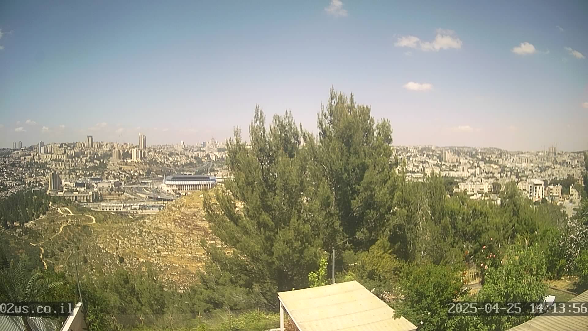
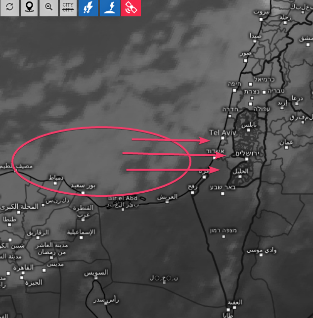
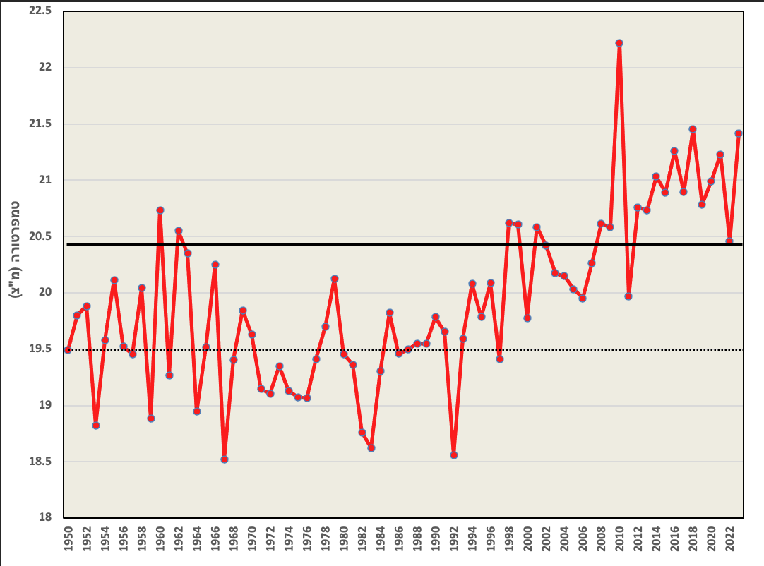
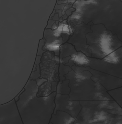


